
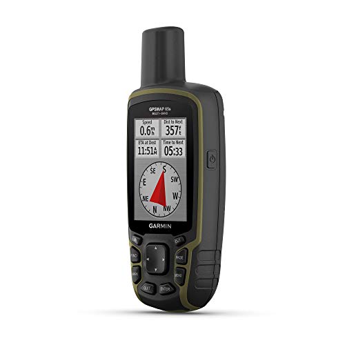
Explore the world with confidence using the Garmin GPSMAP 65s, a top-tier handheld GPS device engineered for outdoor enthusiasts and professionals alike. With dimensions of 7.04 x 5.44 x 2.29 inches and weighing just 7.7 ounces, this compact yet powerful device is designed to withstand the rigors of outdoor adventures.The GPSMAP 65s boasts a large 2.6-inch sunlight-readable color display, making it easy to view maps and data even in bright conditions. Its button-operated interface ensures reliable performance in all weather conditions, allowing you to navigate with ease.One of the standout features of the Garmin GPSMAP 65s is its expanded global navigation satellite systems (GNSS) support and multi-band technology. This advanced capability provides optimal accuracy in challenging locations such as steep terrains, urban canyons, and dense forests. Whether you're hiking, geocaching, or exploring remote areas, you can trust the GPSMAP 65s to deliver precise location data.The device comes preloaded with TopoActive mapping and federal public land maps (U.S. only), providing detailed information on terrain contours, topographic elevations, summits, parks, coastlines, rivers, lakes, and geographical points. Additionally, the integrated ABC sensors (altimeter, barometer, and compass) further enhance your navigational capabilities by offering real-time data on elevation changes and atmospheric pressure.Stay connected with wireless technologies like Bluetooth and ANT+, which enable compatibility with the Garmin Explore website and app (compatible smartphone required). This allows you to manage tracks, routes, waypoints, and review statistics from your excursions seamlessly.The Garmin GPSMAP 65s includes essential accessories such as a USB cable for charging and data transfer, a carabiner clip for easy attachment to gear, and comprehensive documentation to get you started.In conclusion, the Garmin GPSMAP 65s is an exceptional choice for anyone seeking a reliable and feature-rich handheld GPS unit. Its robust design, advanced satellite support, detailed mapping capabilities, and wireless connectivity make it an indispensable tool for navigating the great outdoors.


Key Info
Seller
OnAdventure
OnAdventure
Update
May 16, 2025
May 16, 2025
Amazon Reviews
4.4 (232 Total Reviews)
4.4 (232 Total Reviews)
Categories
GPS Units
GPS Units
Brands
NA
NA
Recent Sales
100+ bought in past month
100+ bought in past month
Product ID
B08HR5CXCK
B08HR5CXCK
Report
Report a Problem
Report a Problem
Other offers of Garmin GPSMAP 65s, Button-Operated Handheld with Altimeter and Compass, Expanded Satellite Support and Multi-Band Technology, 2.6" Color Display
Escape To Nature
Price Updated: May 16, 2025
Avg. Rating: 5 / 5
Total Reviews: 2,731
IPC-STORE✅
Price Updated: May 16, 2025
Avg. Rating: 4.5 / 5
Total Reviews: 25,624
SpddyS LLC
Price Updated: May 16, 2025
Avg. Rating: 4.5 / 5
Total Reviews: 2,722
Deff Audio
Price Updated: May 16, 2025
Avg. Rating: 4.5 / 5
Total Reviews: 2,035
The Factory Depot
Price Updated: May 16, 2025
Avg. Rating: 3.5 / 5
Total Reviews: 134,273
VirVentures
Price Updated: Feb 14, 2025
Avg. Rating: 4.5 / 5
Total Reviews: 175,243
Diddly Deals
Price Updated: Jan 31, 2025
Avg. Rating: 4.5 / 5
Total Reviews: 5,211
Electronic Express
Price Updated: May 16, 2025
Avg. Rating: 4.5 / 5
Total Reviews: 91,574
WhoIsCamera
Price Updated: Feb 14, 2025
Avg. Rating: 4.5 / 5
Total Reviews: 7,545
Sports-and-Gadgets
Price Updated: May 16, 2025
Avg. Rating: 5 / 5
Total Reviews: 11,225
DealsDailyUS
Price Updated: Feb 14, 2025
Avg. Rating: 4.5 / 5
Total Reviews: 2,752
Hunting_Stuff
Price Updated: May 16, 2025
Avg. Rating: 5 / 5
Total Reviews: 25,057
GPS City
Price Updated: May 16, 2025
Avg. Rating: 5 / 5
Total Reviews: 54,611
Tech-Boutique
Price Updated: Feb 14, 2025
Avg. Rating: 5 / 5
Total Reviews: 2,672
DailyPawn
Price Updated: Jan 31, 2025
Avg. Rating: 4 / 5
Total Reviews: 1,353
Amazon.com
Price Updated: May 16, 2025
Avg. Rating: N/A / 5
Total Reviews: 0
More About Garmin GPSMAP 65s, Button-Operated Handheld with Altimeter and Compass, Expanded Satellite Support and Multi-Band Technology, 2.6" Color Display
The Garmin GPSMAP 65s is a rugged, button-operated handheld GPS device designed for optimal accuracy and navigation in challenging environments. It features multi-band technology, expanded satellite support, and a range of mapping capabilities.
Rate the Product
Add Comment & Review
User Reviews
Based on 0 reviews
No reviews added yet.
Comments will not be approved to be posted if they are SPAM, abusive, off-topic, use profanity, contain a personal attack, or promote hate of any kind.


More »

Popular Products

Racquetball Wristlacer4.4 (155 Total Reviews)

HEAD CPS Heat Racquetball Racquet4.5 (68 Total Reviews)

Precise M5 Men's Complete Golf Clubs Package Set Includes Titanium Driver, S.S. Fairway, S.S. Hybrid, S.S. 5-PW Irons, Putter, Stand Bag, 3 H/C's4.3 (1229 Total Reviews)

Bodyprox Elbow Brace 2 Pack for Tennis & Golfer's Elbow Pain Relief4.4 (29412 Total Reviews)

Wilson Advantage Tennis Bag Series4.5 (4313 Total Reviews)

Protec 360 Eyewear™ The Ultimate Eye Protection for Pickleball — Featuring Patented “Open Lens” Technology3.7 (64 Total Reviews)

Dunlop Sports Beginner Squash Racquet Set (Includes 2 Racquets, 2 Eyeguards, 1 Ball, Cover)4.4 (191 Total Reviews)

Stanley Quencher H2.0 Tumbler with Handle & Straw 30 oz | Twist On 3-Way Lid | Cupholder Compatible for Travel | Insulated Stainless Steel Cup | BPA-Free | Mist

Sports Goggles Racquetball Glasses Men Women Safety Eyewear Basketball Racketball Goggles Windproof Adjustable Strap5 (1 Total Reviews)

Riddell 32 Piece NFL Helmet Tracker Set - Gumball Size Helmets - All NFL Current Logo's - New 2023 Set4.6 (519 Total Reviews)

 Badminton
 Handball
 Racquetball
 Squash Sport
 Tennis
 Badminton Nets
 Badminton Rackets
 Badminton Shuttlecocks
 Complete Badminton Sets
 Racquetball Gloves
 Racquetball Rackets
 Racquetballs
 Squash & Racquetball Goggles
 Squash Balls
 Squash Equipment Bags
 Squash Racquet Grips
 Squash Racquets
 Tennis Rackets
 Golf
Golf Swimming
 Yoga
Yoga HEAD
HEAD Python Racquetball
 PENN
PENN WILSON
 Yonex
Yonex Franklin Sports